
Where the Water Goes Matters: Creek, Drainage, Flood Risk, and the Phillip Road Site
When rain falls on a growing city, it does not read the zoning code. It follows gravity, pavement, pipes, channels, floodplains, and the public infrastructure that is supposed to keep water from becoming someone else’s emergency.
That is why creek, drainage, and flood-risk questions deserve close attention in the environmental review of the proposed Phillip Road Site project at 6382 Phillip Road. The proposed mixed-use project includes residential, retail, medical-office, and “innovation center” uses, as well as a new roadway bridge across Pleasant Grove Creek and the Pleasant Grove Creek Bypass Channel. The City’s Draft Environmental Impact Report, or DEIR, describes Pleasant Grove Creek and the bypass channel as running east to west through the site, dividing it into northern and southern portions. Portions of the creek and bypass channel are within FEMA-designated flood-hazard areas. (Phillip Road Project DEIR – Hydrology and Water Quality)
Roseville’s flood history is not theoretical. In January 1995, Roseville experienced a historic flood that damaged 358 structures after approximately 19 inches of rain fell by mid-month, according to the City. The City has since identified floodwalls, levees, bypass channels, stream widening, and creek maintenance among the investments made to reduce future risk. (City of Roseville: “30 Years of Flood Preparedness”) CBS Sacramento’s historical reporting also documented the high-water mark left by the 1995 event near Cirby Creek and City infrastructure improvements made in response.
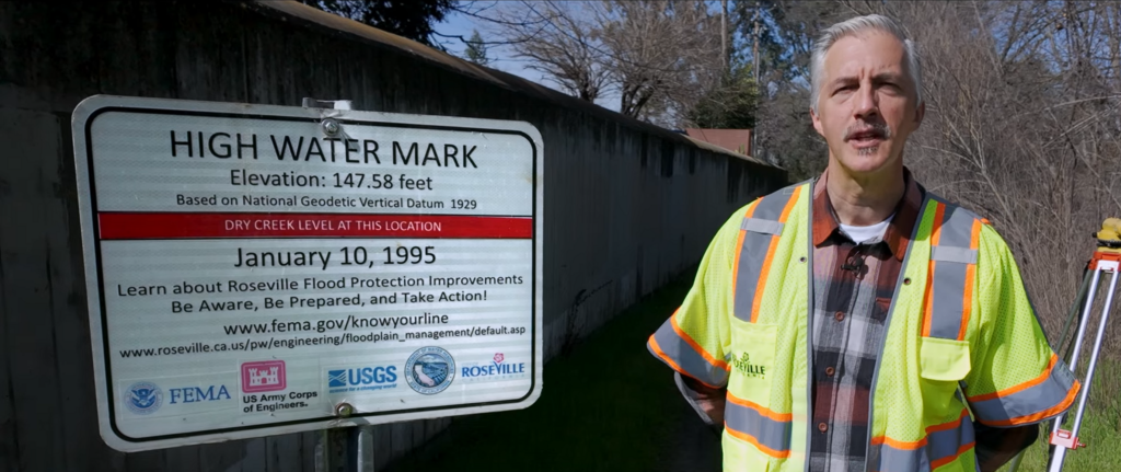
The point is not to claim that Pleasant Grove Creek has caused the same structural flooding seen elsewhere in Roseville. The City has stated that its floodplain-management measures have helped protect structures along Pleasant Grove Creek. The relevant point is more practical: Roseville has experienced serious flooding, has spent decades addressing flood risk, and should evaluate new impervious surfaces, creek crossings, drainage outfalls, and regional mitigation with care.
The DEIR identifies this exact concern. Under Impact 3.12-3, it concludes that the project could substantially alter drainage patterns in a manner that could cause substantial flooding, additional polluted runoff, or exceedance of stormwater-drainage capacity. The DEIR therefore identifies the impact as potentially significant before mitigation. Its proposed mitigation includes potential University Creek realignment, revised grading and lot design if that realignment has not occurred, and the purchase of 29 acre-feet of retention credits in the planned Pleasant Grove Stormwater Retention Basin Facility. The DEIR concludes that the impact would be less than significant after mitigation.
That conclusion is important. So are its assumptions.
The City’s records show that the Pleasant Grove/Curry Creek drainage-fee program has been in place for decades. The City’s 2024 Notice of Preparation states that the fee program was adopted in May 1990 and that the City began collecting drainage impact fees for a watershed-wide solution to downstream flood impacts. The City’s current retention-basin project page states that it has collected permit-based fees within the watershed since 1991 to help fund construction. (Pleasant Grove Stormwater Retention Basin Project)
The most recent City Development Impact Fee Report provides a useful but carefully limited financial snapshot. For the fiscal year ending June 30, 2025, the Pleasant Grove/Curry Creek Watershed Drainage Mitigation Fee account reported:
- $1,533,406 in fees collected during that fiscal year;
- $394,579 in interest earned;
- $2,217,403 spent on the Pleasant Grove Stormwater Retention Facility during that fiscal year; and
- an ending account balance of $16,966,833.
(City of Roseville Annual Development Impact Fee Report, FY ended June 30, 2025)
Those figures should be described accurately. The $16.97 million amount is the reported account balance as of June 30, 2025, not a published all-time total of every drainage-mitigation fee collected since 1991. The City’s cited annual report identifies the year’s collections and the then-current fund balance; it does not present a single lifetime cumulative fee-collection number.
The City estimates the retention-basin project will cost approximately $79 million and states that grants will also contribute to funding. The City’s DEIR further states that the retention basin had been preliminarily designed and environmentally reviewed but had not been constructed as of the DEIR’s preparation. The City’s current project page states that it is preparing a Subsequent EIR for the facility. (City retention-basin project page)
This is where the public comments become especially relevant.
The Save Reason Farms document library currently features Public Comment Letter #1, the Center for Biological Diversity’s DEIR comment letter, and Public Comment Letters #2 through #12. They address different subjects, but they share a central concern: whether the DEIR relies too heavily on future plans, later approvals, fees, assumptions, and mitigation that residents cannot yet evaluate in concrete terms. (Save Reason Farms DEIR public-comment library)
The featured comments raise questions about project-driven planning, future infrastructure demand, student walking and bicycling safety, the meaning of the proposed “innovation” designation, deferred mitigation, neighborhood quality of life, proximity of advanced manufacturing to homes and schools, localized health effects, enforceable CEQA mitigation, solar commitments, on-site greenhouse-gas reductions, and whether the DEIR shifts too much risk to the public. Those are commenters’ positions, not adopted City findings. But they all point toward one test that matters for creek, drainage, and flood review: can the public see, understand, and evaluate the protections before approval rather than reconstruct them after the fact?
For Pleasant Grove Creek and the surrounding drainage system, the practical questions are straightforward:
- Will drainage facilities be fully designed, funded, permitted, constructed, inspected, and maintained before new development increases runoff?
- What protections apply if the regional retention basin is delayed?
- How will construction avoid degrading water quality in or near the creek?
- How will the City demonstrate that retention credits correspond to real, available stormwater capacity?
- And who is accountable for ensuring that EIR commitments are implemented as written?
Those are not predictions of failure. They are the questions responsible environmental review is meant to answer.
Creeks do not negotiate, and floodplains do not accept vague assurances. Before any final approval, the record should clearly show what will protect Pleasant Grove Creek, manage runoff, reduce flood hazards, and ensure that mitigation is more than a promise with good intentions.