Roseville residents do not want industrial development on Reason Farms Panhandle because this parcel is too close to land protected by conservation easements, creeks, neighborhoods, schools, existing parks, and proposed new parks.
Where is the Phillip Road Site?
- Phillip Road Site — also known as the Reason Farms Panhandle — is located at 6382 Phillip Road in Roseville, California.
- Phillip Road Site consists of 237.3 acres on the parcel identified by Placer County Assessor as APN 017-101-008-000.
For visual reference and context check out the below maps.
Phillip Road Site (aka Reason Farms Panhandle) is adjacent to conservation easements, residential neighborhoods, schools, Pleasant Grove Creek Floodplain, existing parks, and proposed parks.
Panattoni Development Company (“Panattoni”) has proposed industrial development on this parcel owned by the City of Roseville (“City”). This parcel is zoned as Public/Quasi-Public.
Panattoni has also proposed that City roads could be used as trucking corridors, including Blue Oaks Blvd, Phillip Road, Westbrook Blvd, and Baseline Rd.
Unlike existing warehouse and distribution sites previously zoned as industrial in Roseville, the Phillip Road Site (aka Reason Farms Panhandle parcel) is much further from the freeway and way too close to existing residential areas.
This proposed industrial park project threatens Roseville’s reputation as a clean, quiet, residential place to live.
What is most striking about this proposed industrial park plan is an apparent lack of concern about causing and exacerbating pulmonary diseases as well as the increased risks for developing certain types of cancer. Many community members are also very concerned about the significant adverse impacts such industrial development could have on air quality, noise, and vibration. Greenhouse gas emissions from a trucking center would not be good for our children at nearby playgrounds and our seniors who enjoy walks in the nearby parks.
We think this parcel should remain zoned as Public/Quasi-Public.
Panatonni is one of the most active private industrial developers in the United States. Panattoni entered into an exclusive option contract with the City of Roseville (the “City”) to develop the Phillip Road Site (aka Reason Farms Panhandle) as an industrial park.
We think the City should promptly terminate the exclusive option contract with Panattoni.
The City and its Councilmembers have the power to exercise reasonable discretion on behalf of the citizens. If necessary, by way of a ballot measure Roseville citizens have the power to directly exert control over zoning decisions.
City Councilmembers are aware that Roseville citizens want this Phillip Road Site (aka Reason Farms Handle) to be protected and preserved for future generations, NOT transformed into an industrial park.
Roseville is neither a trucking hub nor a thoroughfare for trucks.
Just essential trucks that deliver goods to businesses in Roseville should be allowed to operate on our City’s roadways.
Panattoni’s proposed industrial development on this parcel is an avoidable disaster for endangered species in this area.
Industrial use on Phillips Road Site (aka Reason Farms Panhandle) would result in excessive pollutants, traffic congestion, and wear and tear on our our roads.
Untenable would be the serious adverse impacts to us — the humans and citizens of the City of Roseville.
The California Environmental Quality Act (CEQA) is intended to inform government decisionmakers and the public about the potential environmental effects of proposed activities and to prevent significant, avoidable environmental damage.
An Environmental Impact Report (EIR) submitted to California Governor’s Office of Planning and Research identified numerous, substantial adverse impacts that could not be effectively mitigated if this City-owned property were to be rezoned as industrial.
- Panattoni’s proposed industrial use of the Phillip Road Site is inconsistent with the City of Roseville General Plan for 2035.
- Phillip Road Site (aka the Reason Farms Panhandle parcel) is adjacent to residential neighborhoods and near land protected by Reason Farms Conservation Easement.
- Water in Pleasant Grove Creek flows through this 237.3 acre parcel known as the Phillip Road Site (aka Reason Farms Panhandle).
2023 Multi-Hazard Mitigation Plan
The City of Roseville has provided information about local hazards, using the same data that informs local emergency management planning.
All information included here is sourced either from the City of Roseville, ESRI, California Department of Conservation, USGS, Hazus v5.1, or FEMA DFIRM. All data sets were developed or acquired between Sept. 2022 and May 2023.

Source: Interactive Hazards Map | 2023 Multi-Hazard Mitigation Plan Update (arcgis.com)
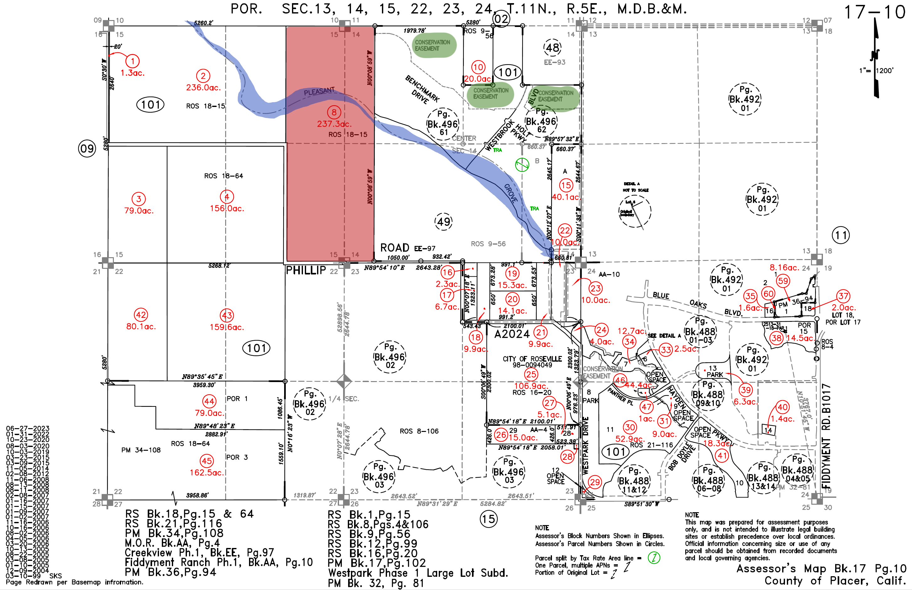
County of Placer, California
Assessor’s Map Bk. 17 Pg. 10
This map shows that the Phillip Road Site is adjacent to Conservation Easement and the Al Johnson Wildlife Area.
City of Roseville,
Bureau of Land Management
This map shows location of these parcels of land and connection to the Pleasant Grove Creek Watershed.
- Phillip Road Site (also known as Reason Farms panhandle), at APN 017-101-008-000. Current land use: farmland.
- Al Johnson Wildlife Area, at APN 017-101-002-000. Current land use: rice crop.
- Reason Farms Environmental Preserve, at APN 017-010-023-000. Current land use: Environmental Preserve

Recreation in Roseville
Industrial development on Phillip Road Site is incompatible with quality of life and recreation in Roseville, California
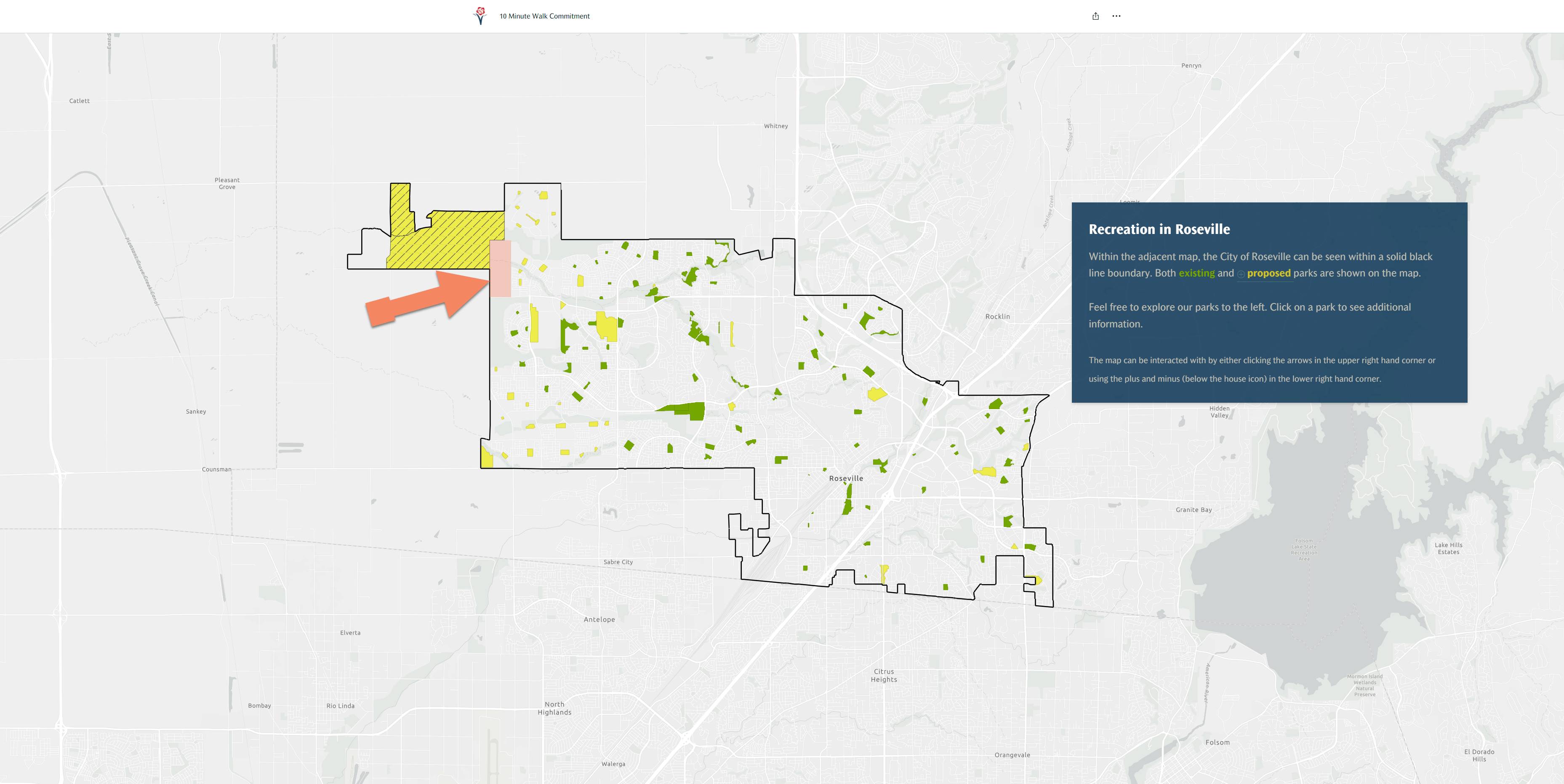
Recreation in Roseville – Existing and Proposed Parks
Source: https://storymaps.arcgis.com/stories/786a00ca245a4aa99d3ae6048233380e)
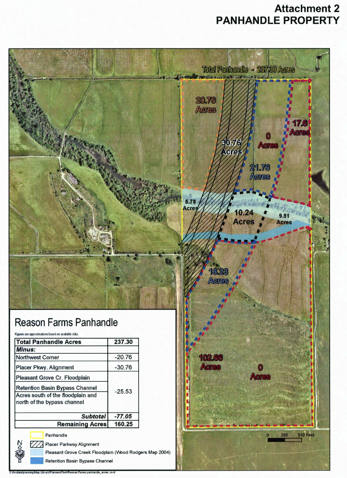
Reason Farms Panhandle
This map depicts the Reason Farms Panhandle parcel (237.3 acres of farmland), the Pleasant Grove Creek Floodplain (circa 2004), and a Retention Basin Bypass Channel.
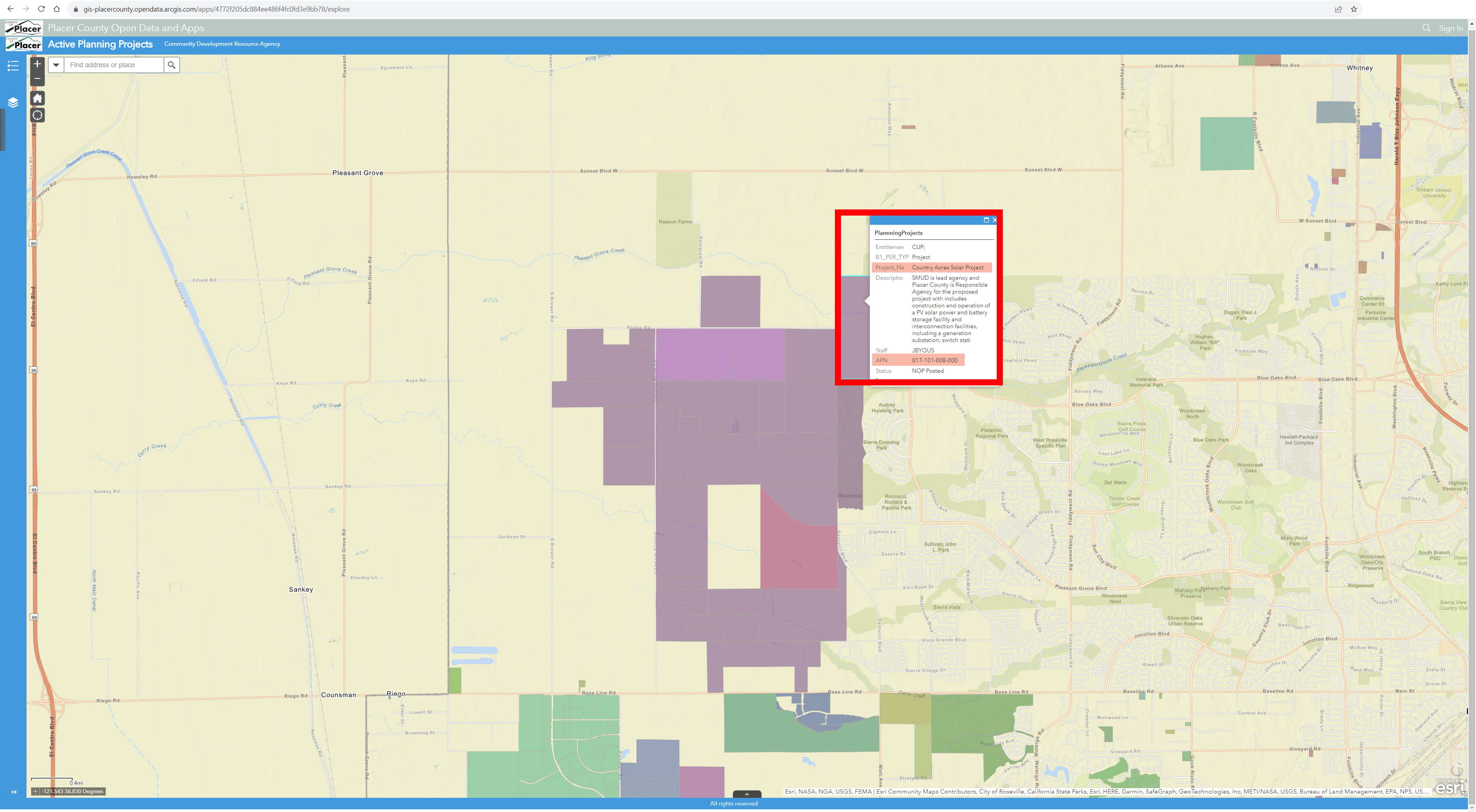
Sacramento Municipal Utility District (SMUD): Country Acres Solar Project
As described by Sacramento Municipal Utility District (SMUD) in its Country Acres Solar Project EIR (September 2022):
“The City of Roseville owns this land, and Placer Land Trust holds the Conservation Easement preventing development and promoting habitat restoration. Reason Farms is part of over 2,000 contiguous acres of permanently protected habitat and an additional 1,700 acres currently maintained as open space by the City of Roseville. The property preserves grasslands, oak woodlands, and vernal pools and riparian habitat.”
Depicted in light purple on the below map, Sacramento Municipal Utility District (SMUD) is proposing the Country Acres Solar Project, which would include installation, operation, and maintenance of a photovoltaic (PV) solar power facility in southwestern Placer County.