Phillip Road Site is an absurd location for fatally flawed industrial project.

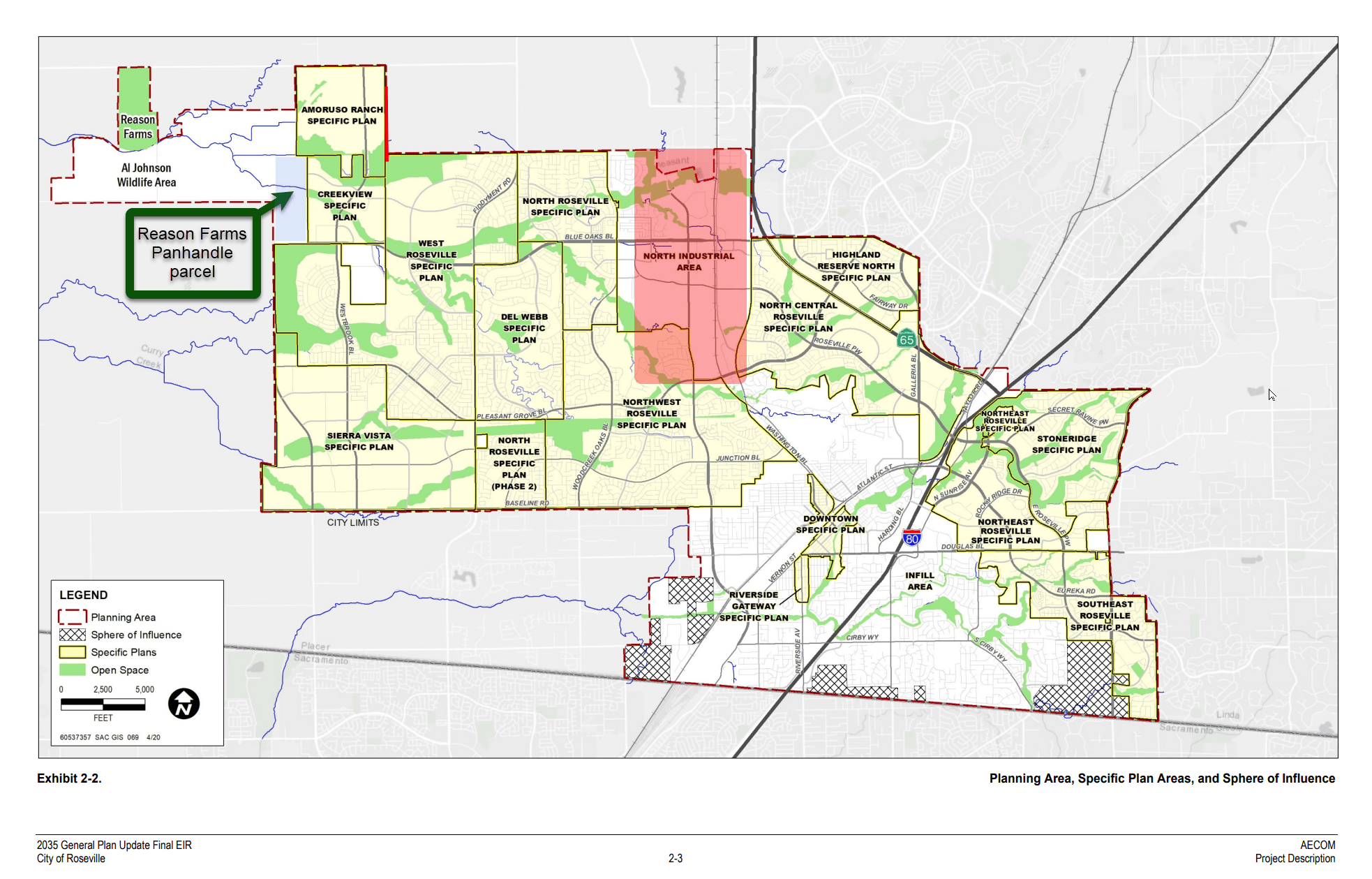
Save Reason Farms is pursuing actions to stop the proposed industrial rezoning of the Roseville-owned property located at 6382 Phillip Road in Roseville, California. The Phillip Road Site parcel is also known as the Reason Farms panhandle. The Phillip Road Site is an absurd location for this fatally flawed industrial project.
If City Councilmembers were to rezone the Phillip Road Site as industrial, quality of life would become very bad for Roseville residents. The City of Roseville General Plan 2035 would have to be amended in order to rezone this Public/Quasi-public parcel of farmland to industrial. Rezoning would be very bad.
Major problems with rezoning from farmland to industrial include but are not limited to the following:
- Rezoning from farmland to industrial the Phillip Road Site would harm Roseville residents, adversely impact health and safety.
- It is estimated that Sensitive Groups including 6,732 students and 8,075 seniors living in the area would be impacted, in addition to day care centers and public recreation facilities.
- Rezoning this parcel would financially benefit Panattoni Development Company, which is a privately held real estate developer specializing in industrial real estate and warehouses.
- In an August 15, 2023 email to the Economic Development Director for the City of Roseville from the California Housing and Community Development (HCD), HCD stated, “it appears the proposed disposition of the site may be in conflict with the SLA”, referring to the California Surplus Land Act.
On March 3, 2021, Roseville Councilmembers passed Resolution No. 21-080 that authorized the City Manager (Dominick Casey) to execute an Option and Purchase and Sale Agreement (“Purchase Agreement”).
This Purchase Agreement is now the focus of intense public scrutiny and there is a groundswell of civic action to terminate it.
This Purchase Agreement pertains to the Roseville-owned Phillip Road Site property located at 6382 Phillip Road (also referred to as the Reason Farms panhandle).
- The subject property is currently zoned Public/Quasi-Public.
- Nearby schools, day care centers, elderly care facilities, and public recreation facilities.
- The Purchase Agreement is contingent on the purchaser (Panattoni) requesting that the property be rezoned to an industrial designation.
- As stated in the Purchase Agreement, the property includes “all of Seller’s right, title and interest in any assignable licenses, permits, mineral rights, water rights or shares, easements, rights-of way…”
- Pleasant Grove Creek contains water that flows across the Phillip Road Site.
- Panattoni was required to deposit just $50,000 with the title company to lock in an exclusive option contract to purchase the Phillip Road Site property at 6382 Phillip Road.
- The first phase of 35 acres is expected to result in $1,243,165 ($34,519/acre).
RECOMMENDED ACTIONS FOR ROSEVILLE COUNCILMEMBERS
(a) Approve a City Council motion to terminate the contract between the Panattoni Development Corporation (PDC Sacramento LPIV, LLC) and the City relating to a proposed industrial park on the Phillip Road Site (APN 017-101-008-000), which is also known as the Reason Farms panhandle parcel; and
(b) Approve a City Council motion to keep the Phillip Road Site parcel (APN 017-101-008-000) zoned as Public/Quasi-Public farmland until such time that other developers’ ideas can fully be evaluated by the City’s Councilmembers and its planning team; and
(c) Consider for the Phillip Road Site parcel only non-industrial land uses that will keep Roseville residents safe, healthy, and happy.
According to the Attorney General for the State of California, Department of Justice, City of Roseville should heed this guidance for proper land use:
“Establish industrial districts NEAR MAJOR HIGHWAY AND RAIL CORRIDORS, but AWAY FROM SENSITIVE RECEPTORS”
Rob Bonta, Attorney General (September 2022)“Sensitive Receptors” include hospitals, schools, day care centers, elderly care facilities, public recreation facilities, and other such locations. Sensitive receptors are children, elderly, asmatics and others whose are at a heightened risk of negative health outcomes due to exposure to air pollution. The locations where these sensitive receptors congregate are considered sensitive receptor locations. Sensitive Receptor locations may include hospitals, schools, and day care centers, and such other locations as the air district board or California Air Resources Board (CARB) may determine (California Health and Safety Code § 42705.5(a)(5)).
The Phillip Road Site parcel is too FAR FROM MAJOR HIGHWAY AND RAIL CORRIDORS and DANGEROUSLY CLOSE TO SENSITIVE RECEPTORS.
Under California state law: “[E]nvironmental justice” means the fair treatment of people of all races, cultures, and incomes with respect to the development, adoption, implementation, and enforcement of environmental laws, regulations, and policies. (Gov. Code, § 65040.12, subd. (e)).
“[I]mprudent warehouse development can harm local communities and the environment. Among other pollutants, diesel trucks visiting warehouses emit nitrogen oxide (NOx) — a primary precursor to smog formation and a significant factor in the development of respiratory problems like asthma, bronchitis, and lung irritation—and diesel particulate matter (a subset of fine particular matter that is smaller than 2.5 micrometers) — a contributor to cancer, heart disease, respiratory illnesses, and premature death. Trucks and on-site loading activities can also be loud, bringing disruptive noise levels during 24/7 operation that can cause hearing damage after prolonged exposure. The hundreds, and sometimes thousands, of daily truck and passenger car trips that warehouses generate contribute to traffic jams, deterioration of road surfaces, and traffic accidents.”
For best practices about warehouse siting and design considerations and air quality and greenhouse gas emissions, see CA DOJ’s Warehouse Projects: Best Practices and Mitigation Measures to Comply with the California Environmental Quality Act (CEQA)
Phillip Road Site is an absurd location for this fatally flawed industrial project.
The subject Phillip Road Site (aka Reason Farms Panhandle parcel) is an inappropriate location for warehousing and distribution, or any other industrial use.
City of Roseville currently has enough industrial space. Smart Growth principles require that the City of Roseville not rezone as industrial the Phillip Road Site (aka Reason Farms Panhandle parcel).
Plenty of Available Industrial Space in Roseville
- Roseville residents think the City should make use of the 11+ million square feet of locally available industrial real estate before considering the creation of new industrial space.
- Any new industrial space would need to be sited far away from hospitals, schools, day care centers, elderly care facilities, public recreation facilities, and other such locations.
- The Property at 6382 Phillip Road (aka Phillip Road Site, aka Reason Farms Panhandle) is currently zoned as Public/Quasi-Public and it is an inappropriate location for industrial development.
| Location | Square Feet |
|---|---|
| Placer Commerce Center Foothills Blvd North & South of Athens Avenue | 6,400,000 SF |
| Williams Health & Technology Center 1451 & 1431 Blue Oaks Blvd / 9100 Foothills Blvd | 900,000 SF |
| Foothills Station Foothills Blvd & Pleasant Grove Blvd | 290,000 SF |
| Crossdock Distribution Building 8891 Foothills Blvd | 154,000 SF |
| Roseville Innovation Center - R1, R3, R5 8000 - 8050 Foothills Blvd (Hewlett Packard) | 220,000+ SF |
| Warehousing / Distribution 8020 Foothills Blvd | 155,000 SF |
| Panattoni Industrial Park 7601 Foothills Blvd (Phase 1) | 149,900 SF |
| Hewlett Packard Campus 9000 Foothills Blvd | 40,994 SF |
| 4-Star Industrial Space 10050 Foothills Blvd | 35,000 SF |
| Blue Oaks Tech Center 9083 - 9089 | 37,980 SF |
| 4-Star Industrial Space 8875 Washington Blvd | 100,800 SF |
| Panattoni Industrial Park 7601 Foothills Blvd (Future Phases Approved at this Location) | 1,079,465 SF |
| Foothills Commerce Center Winding Creek Rd @ Foothills Blvd (Future Phases Approved at this Location) | 1,000,000 SF |
| Roseville 80 (Future Phases Approved at this Location) | 622,250 SF |
| Grand Total | 11,144,395 SF |
City’s Land Use Map shows the substantial existing amount of industrial properties in the North Industrial Zone. According to the City of Roseville General Plan 2035, industrial zones are identified with the acronyms LI, IND, T/BP, and TS. Industrial properties are properly situated next to existing highways and train corridors.
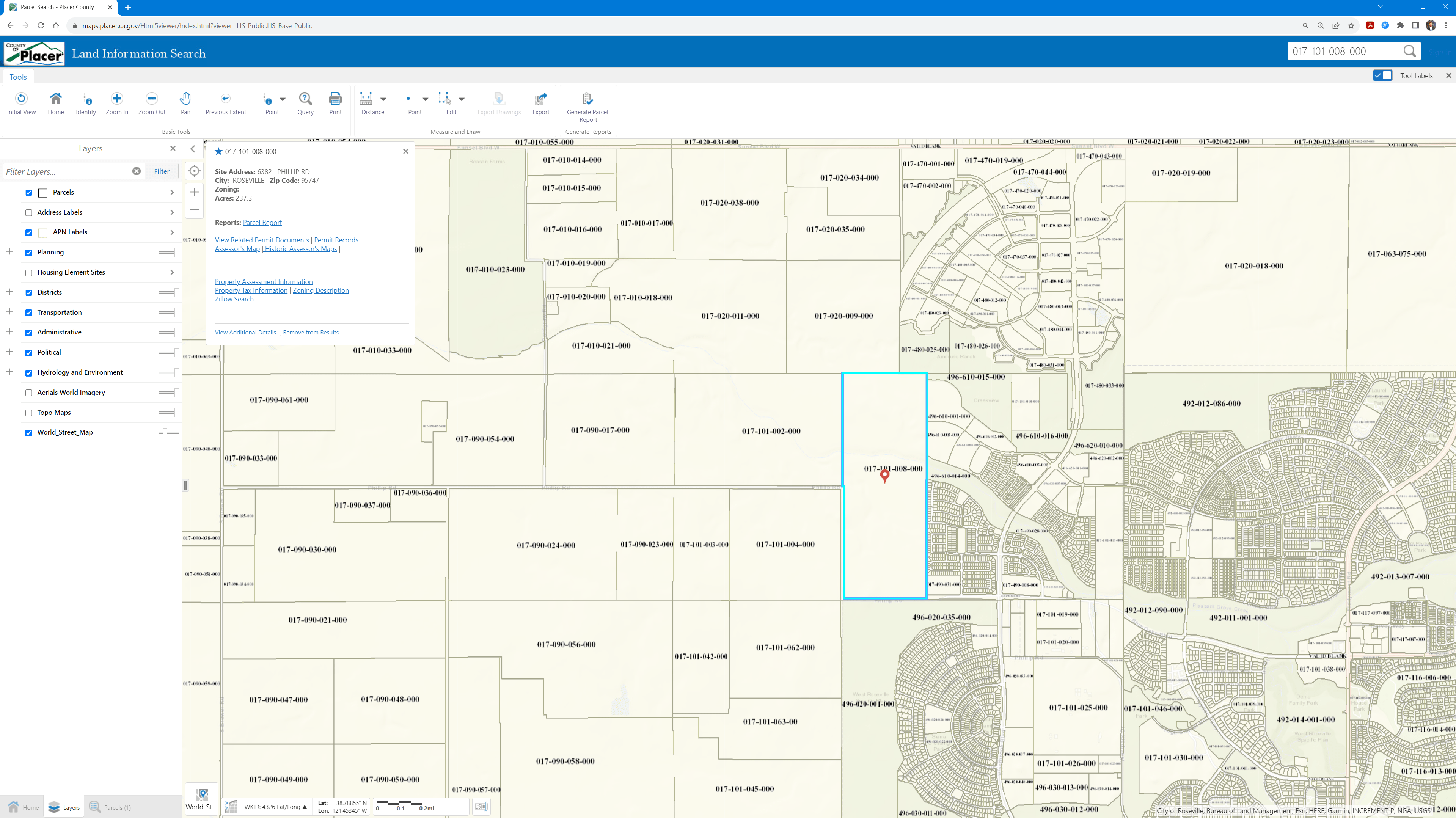
The Property at 6382 Phillip Road (aka the Phillip Road Site, aka Reason Farms Panhandle parcel) can be pinpointed on a map using APN 017-101-008-000. This Property is currently zoned as Public/Quasi-Public (PQP). For the reasons discussed above, it would be environmentally unjust and utterly inappropriate if the City Councilmembers were to rezone as industrial this parcel of Roseville land.
Source: https://maps.placer.ca.gov/Html5viewer/Index.html?viewer=LIS_Public.LIS_Base-Public


